The City of Philadelphia really wants you to think about solar.
A new map shows residents and businesses their solar potential of existing rooftops.
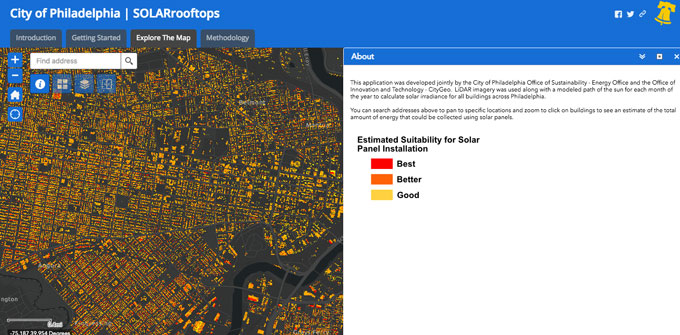
According to the website, the map was developed by the City of Philadelphia Office of Sustainability – Energy Office and the Office of Innovation and Technology – CityGeo using LiDAR imagery with a modeled path of the sun for each month of the year to calculate solar irradiance for all buildings across Philadelphia.
We checked our office building to see what happens. The red spots have the best opportunities for solar panels, followed by orange and yellow. (Looks like we should start talking to our building owners about solar, eh?)
Once you’ve checked your building out on the map, you can check for more local resources to start getting solar energy.
Solarize Philly helps residents go solar at home, making it easy and affordable.
Solar Energy Industries Association has a Solar Customer Resource Portal to outline options, what to look for in an offer, what to ask a solar company and more.
Explore the map and your buildings at Phila.gov/solarmap.
Read the latest sustainability news. Earth Day was Monday is every day, and was celebrated…
Recycling in Philly is broken. Here’s how Mayor Parker’s administration could fix it. Recycling in…
We sat down with Adam Ortiz, EPA's Mid-Atlantic Regional Administrator to chat about transparency and…
Philadelphians' skepticism about the City’s waste policies has led to an abysmal recycling rate. Here’s…
Read the latest local sustainability news. Can you believe the solar eclipse was this past…
With more companies embracing the triple bottom line, finding a career that matches your values…